From my home town of NYC I can hop on a bus that departs the NYC Chinatown going off to the Boston, Philadelphia, and Washington DC Chinatowns. This is a pretty unique way to link similar cultural landscapes together while conquering a topographic distance.
While I realize that in most towns and cities there are other Chinatowns, "Little Italy's", and strong Irish pride districts, I am not aware of any other ethnographic landscape that is linked together by a bus. Returning from Boston I have a new appreciation for the various Chinatown heritage interpretations there are along the Eastern seaboard.
I will be going on a studio field trip, at the end of the week, to Toronto Canada and I have been told that there is a Chinatown there as well. I am hoping if time permits it, to view the Toronto Chinatown landscape with the intention of comparing and contrasting the Chinatowns in Boston and NYC.
edit-
The trip out to Toronto, while very informative, was on too rigid a time schedule to have any daylight hours to sight see. So, I guess this thought will have to be put on the back shelf for now!
Tuesday, March 29, 2011
Friday, March 25, 2011
d.i.y street art.
Some structured procrastination courtesy of my amazing facts.
what other holes can we fill?
what other holes can we fill?
Thursday, March 24, 2011
reading a landscape.
Now that I have had time to synthesize some thoughts on my excursion to Boston allow me to introduce the term cultural geography and then use sites in Boston as examples. Where psycho-geography is the locals tool to be released from the monotony of society; cultural geography is a scope that anyone has access to, to read the landscape.
One of these terms is cultural landscape. A cultural landscape is defined by the National Park Service as "a geographic area, including both cultural and natural resources and the wildlife or domestic animals therein, associated with a historic event, activity, or person, or that exhibit other cultural or aesthetic values." If every landscape can be read see: cultural landschaft pt.two, then every landscape you enter has some sort of cultural significance making it a cultural landscape. Essentially this goes along with the situationist theories for breaking up the monotony for the every day citizen, but a visitor applies the lens of cultural geography to a place.
After this article I would implore all who read it to step outside and use psycho-geography to view the cultural landscapes that make up your neighborhoods. The four categories of cultural landscapes are described below.
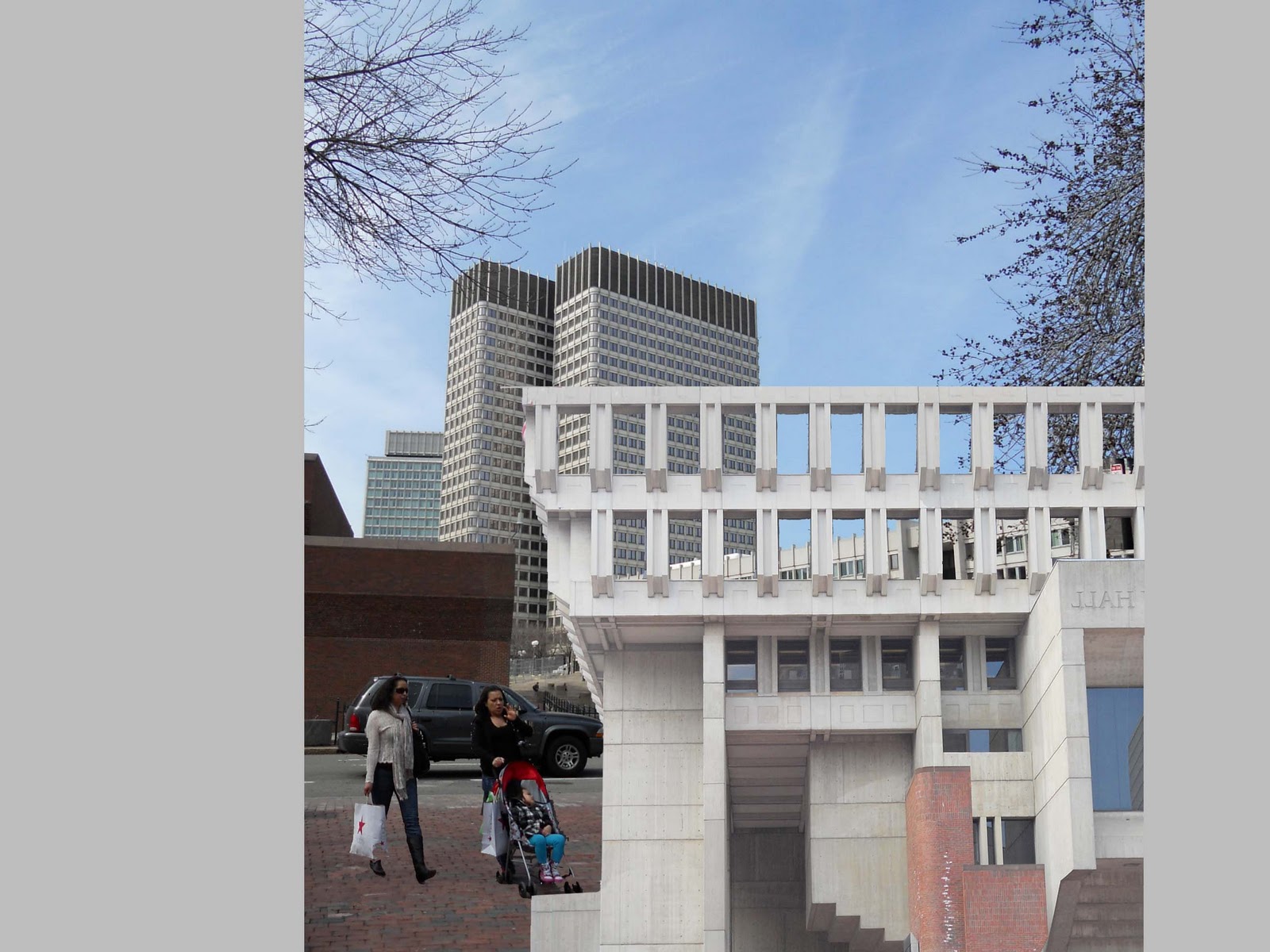
 This graphic represents the first place I entered when I exited the Government Center train station. My mind began to frenzy as I marveled at the Escher-esque government institution, City Hall. As for my interpretation: the architecture has successive jutting angles that make up the floor plans for the interior rooms this represents the laws and regulations that provides order. The reason why this building reminds me of work by Escher similar to this one, is because the inverted architectural details represent that the rules, laws and regulations, under certain circumstances, can be manipulated in favor for the citizen.
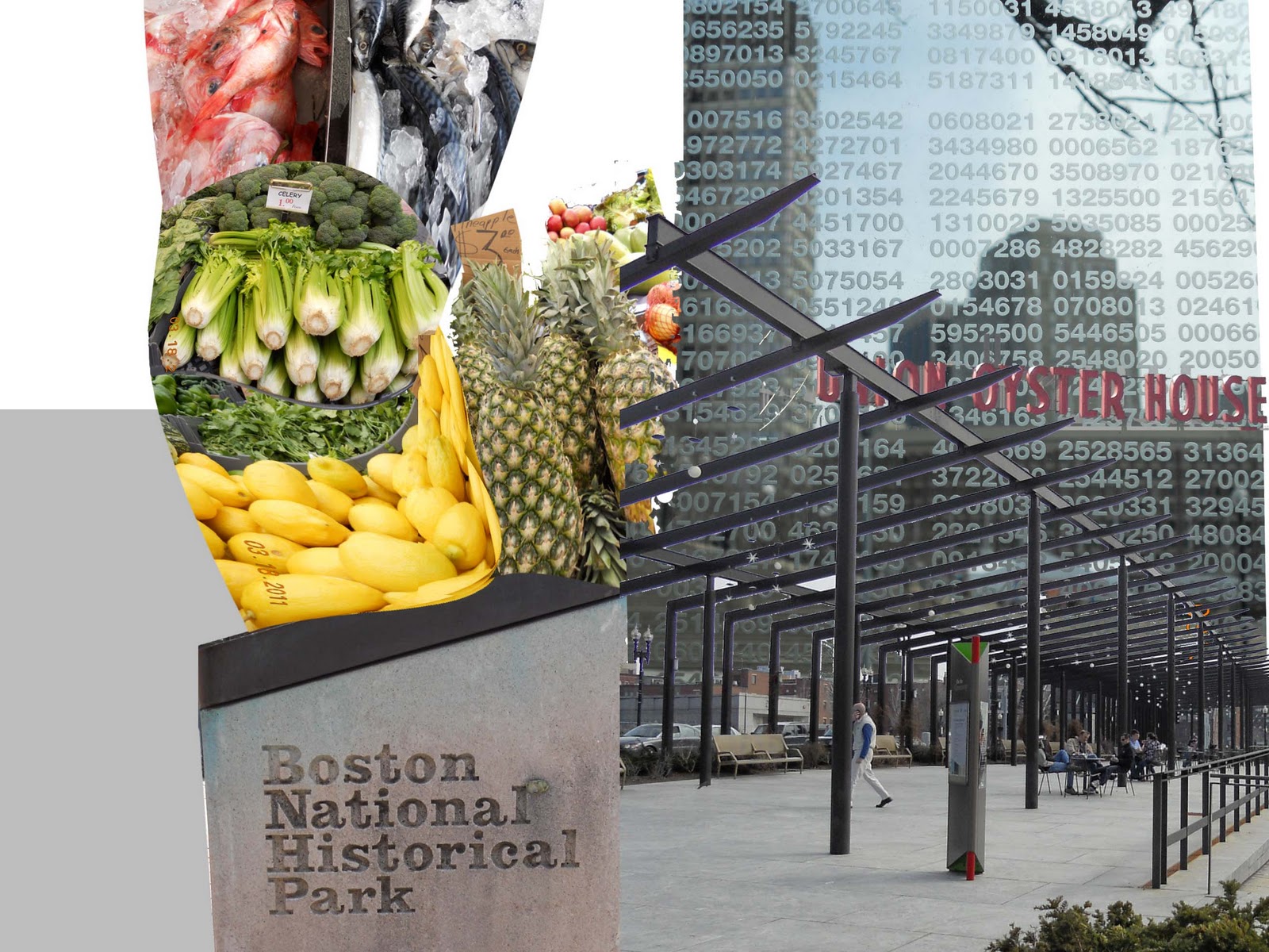
 This represents what I walked into next as I left Gov't Cntr and entered the Union Street district. I would interpret this space as a lively sanctuary for memories of the past. American History, memorials, and Presidential happenings are a few of the features that make up this culture-storical landscape. The area is also notable for a few more reasons: the first is that this is the site of the oldest restaurant in the United States, the Union Oyster House- a site on the National Register of Historic Places. The area is also home to the beginning of the Boston Big Dig, a project that involved re-routing a major thru-way underground. The project was constructed during the course of 30 years. At street level a series of parks reflect the current users' needs reflected through designed using heritage and palimpsest as design precedent. A final facet of this area is that the day I walked through it an open air market was going on, full of fresh fruit, vegetables and the quintessential Boston seafood.
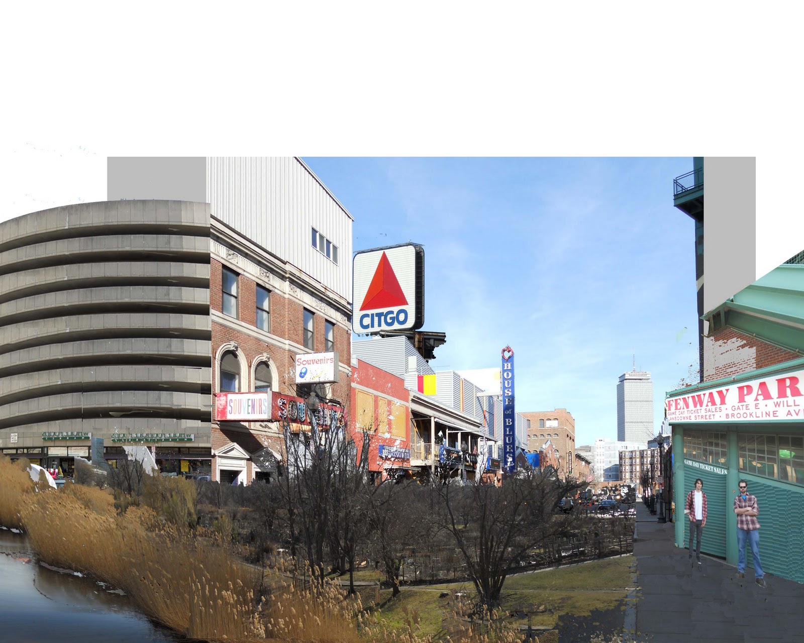
 This final area is focusing on the Fenway ball park district, I was in a rush to visit a buddy who worked in the approximate area so I took the T. The first thing I saw were the allotments at the Fenway Garden Society- the first Victory Garden in the US, an American version of the Dansk allotment garden. Then as I walked further into this district you begin to lose sight of the Citgo sign, a unique landmark in Boston. Finally I entered the district that flanks the Fenway ball park. This is an interesting district because it is not so much a celebration of cultural heritage, rather it is a mosaic of buildings that centers around our National past time.
One of these terms is cultural landscape. A cultural landscape is defined by the National Park Service as "a geographic area, including both cultural and natural resources and the wildlife or domestic animals therein, associated with a historic event, activity, or person, or that exhibit other cultural or aesthetic values." If every landscape can be read see: cultural landschaft pt.two, then every landscape you enter has some sort of cultural significance making it a cultural landscape. Essentially this goes along with the situationist theories for breaking up the monotony for the every day citizen, but a visitor applies the lens of cultural geography to a place.
After this article I would implore all who read it to step outside and use psycho-geography to view the cultural landscapes that make up your neighborhoods. The four categories of cultural landscapes are described below.
- The historic site type is a place that has a historic significance associated with it, Gettysburg, Pa. or the State House of the Province of Pennsylvania otherwise known as Independence Hall in Philadelphia Pa.
- The next type is a historic designed landscape, this is a property that had a notable landscape designer or even a home owner who design the exterior. Spaces designed by Lancelot 'Capability' Brown, Garett Eckbo, and the homes in Dyssekilde, Denmark are some examples.
- The historic vernacular landscape are places and spaces that the locals have designed themselves using the information passed on through the generations. Information such as climate and local resources reflect certain land use patterns. An example of this is the vernacular homes of Norway, or terraced agriculture in China, or any of the US National Parks.
- The final type is an ethnographic landscape which is a place that has traditional cultural values reflected through design to meet the wants of the a demographic in the area. These are areas where the citizens that make up the majority of the demographic imprint on the landscape the heritage they collectively celebrate. Examples of this can be restaurants and landscape/architectural details features, monuments. In Syracuse, NY- Lodi Street is a district that is known for its strong Italian population and it reflects this through Italian markets and bakeries.
 |
| The above graphic is my situationist map unbeknownst to me at the time I walked in a spiral direction, as I recorded the experience of being in a place. Below is my analysis of the various areas I walked through. |
- Government Center Station -- Number One-Historic site/Designed
 This graphic represents the first place I entered when I exited the Government Center train station. My mind began to frenzy as I marveled at the Escher-esque government institution, City Hall. As for my interpretation: the architecture has successive jutting angles that make up the floor plans for the interior rooms this represents the laws and regulations that provides order. The reason why this building reminds me of work by Escher similar to this one, is because the inverted architectural details represent that the rules, laws and regulations, under certain circumstances, can be manipulated in favor for the citizen.
- Union Street -- Number Two-Historic site/Ethnographic
 This represents what I walked into next as I left Gov't Cntr and entered the Union Street district. I would interpret this space as a lively sanctuary for memories of the past. American History, memorials, and Presidential happenings are a few of the features that make up this culture-storical landscape. The area is also notable for a few more reasons: the first is that this is the site of the oldest restaurant in the United States, the Union Oyster House- a site on the National Register of Historic Places. The area is also home to the beginning of the Boston Big Dig, a project that involved re-routing a major thru-way underground. The project was constructed during the course of 30 years. At street level a series of parks reflect the current users' needs reflected through designed using heritage and palimpsest as design precedent. A final facet of this area is that the day I walked through it an open air market was going on, full of fresh fruit, vegetables and the quintessential Boston seafood.
 - Skyline -- Number Three-The Cultural Landscape
This is the view of North Boston from across the waterway. Its awe inspiring to look at a sky line and imagine all the stories people can recall from being inside the areas hidden behind the urban wall. Another aspect to think about is that while you are viewing the city from the distance there are current events that are going on where you could have possibly added to the layers.
- Street Art -- Number Four-Ethnographic
Number four is a compilation of street art I encountered as I walked from North Boston to South Station. Street art is an amazing story anyone can read and gain an understanding of what a minority of people want the rest of us to know. While I find that well done street art is a wonderful addition to the public realm not everyone would share this opinion about any type of street art, well done or otherwise.
- South Street -- Number Five-Historic site
The South Street station is a regional transportation hub in Boston, the building is also on the NRHP for among other reasons; in 1910 it had the most ridership of any other train station in the United States.
- Chinatown walk -- Number Six-Ethnographic/Vernacular
More street art I walked past as I left South Street and head into the Historic Leather District- shortly there after into Chinatown.
- Fenway -- Number Seven-Ethnographic/Historic site
 This final area is focusing on the Fenway ball park district, I was in a rush to visit a buddy who worked in the approximate area so I took the T. The first thing I saw were the allotments at the Fenway Garden Society- the first Victory Garden in the US, an American version of the Dansk allotment garden. Then as I walked further into this district you begin to lose sight of the Citgo sign, a unique landmark in Boston. Finally I entered the district that flanks the Fenway ball park. This is an interesting district because it is not so much a celebration of cultural heritage, rather it is a mosaic of buildings that centers around our National past time.
 Wednesday, March 23, 2011
buffering.
To get to the point right away, creating the content for my trip to Boston is taking longer than I expected; I will be with you readers within the day.
Tuesday, March 15, 2011
not leaving on a jet plane.
For the next four days or so I will be in the Boston, Massachusetts area. My original reason to visit the city was to see a buddy who recently graduated. The trip out there has since then evolved into a cacophony of chance happenings, additions, and overall excitement.
I really don't know how else to describe it without getting into a unnecessarily long blog post.
Basically what I am saying is that the normal pace at which I have been blogging might be slower than normal.
I really don't know how else to describe it without getting into a unnecessarily long blog post.
Basically what I am saying is that the normal pace at which I have been blogging might be slower than normal.
Sunday, March 13, 2011
best waste principle.
It dawned on me today that there are only eight weeks of school left. Not surprising is that this next phase of studio is also our last. The class was broken down into three groups urban agriculture, the regional food hub and the regional food shed. The first and second use Syracuse and begin to step out into the CNY as their focus for design. The regional food shed, the group I am part of, is looking at what the food shed boundaries are considered, what type of existing network is in NYS, finally the potentials of the NYS food shed.

A portion of my part of the food shed project is looking at various commodities agriculture, aquaculture, livestock, dairy, wine, beer- and seeing how NYS, as well as outside precedent uses best waste principles through these sheds. Industry standards put out by the Hiwwasee River Watershed Coalition, out in North Carolina, are rotational grazing. Which is having livestock graze one portion of the field as you let another recover and repeat the process. If done correctly this can have benefits to all involved- the land, the livestock, and the farmer. HRWC also suggest having a buffer zone between grazing lands and general water sources. To take this standard to another level sites for grazing can should be sloped and well drained to collect runoff.
While I am a pragmatist, I think it would be ideal for NYS to become food secure. Meaning that all facets of the food shed production, distribution, marketing, consuming, and waste be taken care of in state. Looking at the definition of food shed that I found on here, according to the 110th Congress local food is either produced within the state boundary or for where it may apply 400 miles from the origin of production. As represented with the graphic to the right there is a huge difference in one from the other, NYS is nowhere near 400 miles across at any point in its geography, for one and for another maybe it would not be so bad to have a better cooperative agreement with the surrounding states. If we continue with the 2008 Congress definition of local food, a NYC resident would be eating local food if it was imported from Ottawa and a Syracuse resident would be eating local food from around the middle of Ohio. If we take it a step further and consider geography and past glacial activity the soils a crop is grown in in Ottawa or Ohio are similar to the soils of NYS.

A portion of my part of the food shed project is looking at various commodities agriculture, aquaculture, livestock, dairy, wine, beer- and seeing how NYS, as well as outside precedent uses best waste principles through these sheds. Industry standards put out by the Hiwwasee River Watershed Coalition, out in North Carolina, are rotational grazing. Which is having livestock graze one portion of the field as you let another recover and repeat the process. If done correctly this can have benefits to all involved- the land, the livestock, and the farmer. HRWC also suggest having a buffer zone between grazing lands and general water sources. To take this standard to another level sites for grazing can should be sloped and well drained to collect runoff.
home.
So as the campus declines into Spring Break I discovered an article, here, on the blog the Responsibility Project.
Hailing from Staten Island I have always kept in the back of my mind that my home town is notorious for being home to the Freshkills landfill. That was what initially sparked my interest in finding out about landscape architecture. Within the last ten years there has been serious progress in changing the use of Freshkill.
For those not in the know the landscape architect in charge is James Corner, whose firm Field Operations also designed High Line park in New York City. The parks design, phased into a 30 year construction plan, offers users opportunities that at one time were difficult to find in the five borough area. The massive 2,200 acre park is only 45 percent brown field while the majority are wetland, creek and swamp. The design balances the present habitats found on the site while discussion with the community developed roadway circulation patterns and program elements such as a boat launch and promenade. The history of the re-design involved an international design competition which began in 2001. The winning design, by Field Operations, utilized the concept of lifescape. Which uses the ecological setting in the urban sphere as the stage for residents to experience and share life. (courtesy of the NYC Department of City Planning)
The park when completed will host five areas the Creek Landing welcomes visitors into the park as well as being the staging point for canoe and boat launching, the Point is the area for sports fields and event spaces. Also important to the Point is the waterfront promenade hosting restaurants and an open air market. North Park will have trails for nature walking and bicycling. South Park is adjacent to Arden Heights, and can host large scale sport events as well as hosting equestrian facilities. East Park is part home to the Staten Island Express Way whose path will be revitalized into an improved scenic drive. The final West park will host a wild flower meadow and an earthwork sculpture for the remembrance of September 11th. The five parks provide views looking out onto sweeping vistas not normally associated with living in a city. (courtesy of the NYC Department of Parks & Recreation)
Wednesday, March 9, 2011
a co-op in syracuse.
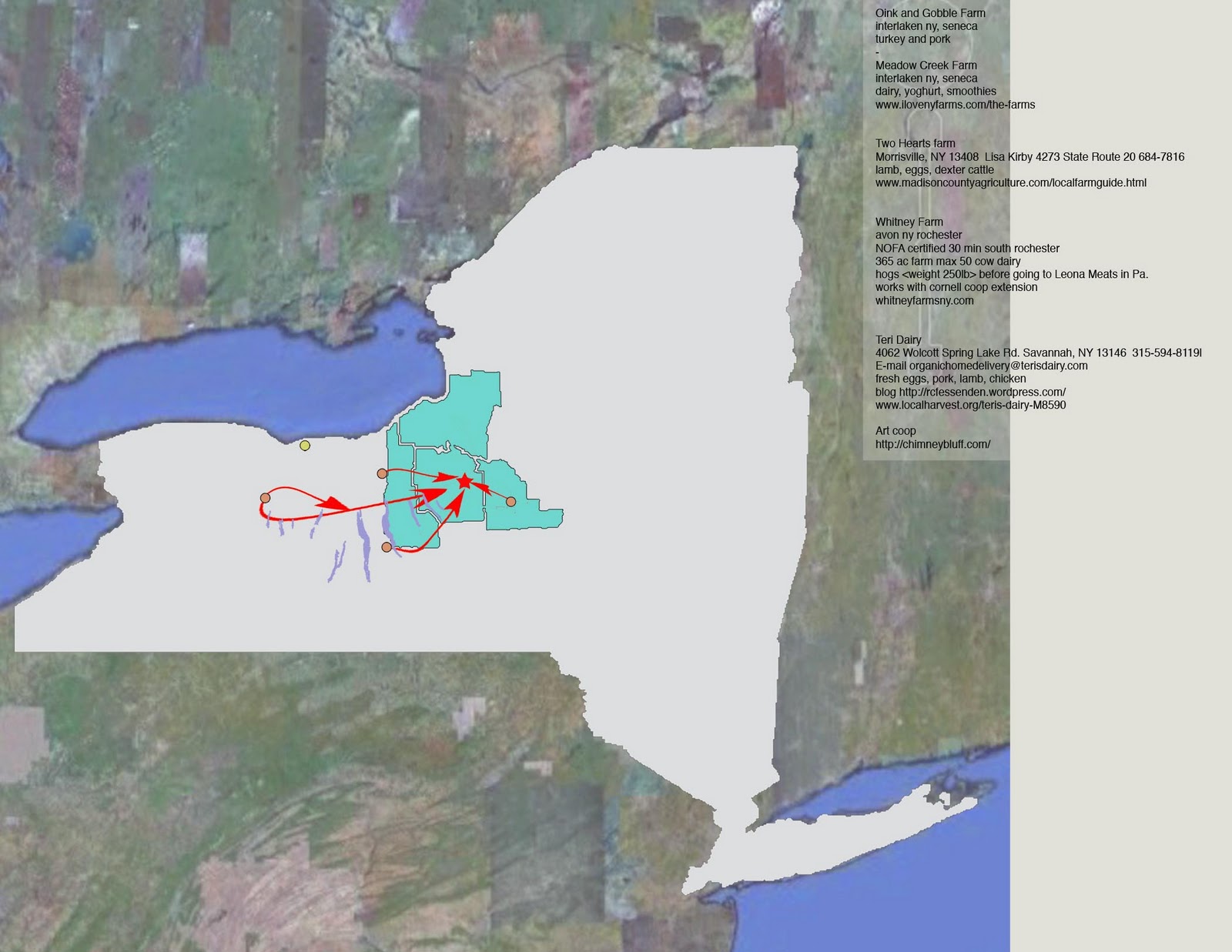 |
| The above graphic looks at which farms the Co-op buys its milk, yoghurt, cheeses, eggs and meats from |
It is located on the edge of a residential neighborhood that opens up to an open space composed of a park and sports field. When I walked in I was greeted right away and the staff was very friendly and responsive to my questions even though it was nine in the morning. One clerk in particular listed and showed me products that they buy from local farmers the majority being dairy and livestock products. While the co-op generally buys local, some farmers ship food out to Pennsylvania.
While it makes the university area less of a food desert, it is a bit more expensive than your average supermarket. Local in season produce, dairy, cheese and meat are all higher priced but only by nickels and dimes. Upon a recent return I was surprised to find some imported from Mexico vegetables that were out of season.
what does CAD have to do with it?


This studio project was from my fourth year, second semester. The studio placed an emphasis on applying Auto CAD to our semester long design project. SUNY ESF is in the process of building a new dormitory, they have gotten very far since breaking ground summer of 2010(Live view of dorm construction). The semester project involved designing an Americans with Disabilities Act egress route in a space measuring 2400 sq ft space. To conquer a 15 foot vertical hight change from street to campus I chose to work with a module design. The module I decided to work with was an elongated triangular copular, which was reflected in the ramp layout, seating areas, planting beds, stairwells and a necessary program element a bus shelter. This portion of the project was part conceptual and part Auto CAD documentation.
 |
| Sketch-up view of ADA access |
 |
| Across the street view |
 |
| The proposed outdoor fitness area at the other end of the ARB |
Then in the second half of the semester we looked at the proposed design for the first ever ESF dormitory, Centennial Hall, and the potential for developing the nearby parking lot on Stadium Place into an Administration Research Building, ARB, for Syracuse University. Factors inventoried in the planning process were microclimate conditions, the potential for the corner of the ARB and Centennial Hall to be an outdoor fitness area, and moving the bus shelter to the other corner of the ARB. The design of the ARB, seating spaces, and planted areas are all based off of the same modular component as the bus shelter and ADA egress route. This modular is a variation of the platonic shapes, i.e. cube, pyramid.
 |
| Proposed design for front entrance of the ARB |
what's abroad?
At the State University of New York College of Environmental Science and Forestry a component of the Bachelors of Landscape Architecture program is a mandatory fifth year of college that puts you out into the world with the skills you have been taught over the previous four years of landscape architecture classes. During the the two semesters that make up the fourth year you write a proposal that involves a topic for you to study over a semester in a foreign country. Providing you can get enough students and a professor as an advisor you can essentially go anywhere in the world. I had suggested and was fortunate enough to find nine students and two advisors to study various topics in Copenhagen, Denmark. The advisor plays a large role in the fourth year by helping us to focus on independent study topics, and during the fifth year semester steps way back and other than letters home visits the group once during the fifth week while we are abroad.
The topic that I chose to focus on were theories proposed by the situationist, a European art group who were involved in student and worker protests during the 1970's. Besides stirring up society they proposed ways to redesign and re-invision the urban fabric. Certain theories I focused on were the Derive, Psychological-Geography and Unitary Urbanism.
The topic that I chose to focus on were theories proposed by the situationist, a European art group who were involved in student and worker protests during the 1970's. Besides stirring up society they proposed ways to redesign and re-invision the urban fabric. Certain theories I focused on were the Derive, Psychological-Geography and Unitary Urbanism.
Monday, March 7, 2011
cultural landschaft pt.two
 |
| A limestone capital and columns gifted from Amman, Jordan to the city of Philadelphia Found in a courtyard on the Penn State campus. |
To bring this into landscape terms the landscape can be read because we have cultivated the world around us. Three examples I want to use to help you understand this concept is the Romantic period where the rich had lavish back yards, the National Parks Service freezing time by preserving "natural" views, and the current trend being suburbanization by making the landscape more suitable for automotive transportation.
Each of these time periods' landscapes can be read because of the cultural significance of that time.
Romantic periods are identified because people that had money wanted certain views to bring them back to a nostalgic time period they were never a part of, basically another time periods culture. These landscapes are notorious for moving the earth to introduce ponds, farm animals, boulders, and hills into landscape where these features may not have been natural. Another idea introduced to the romantic landscapes were Greek or "ancient" architectural ruins- the idea for this is that it was once born out of the earth and through erosion it will be brought back into the earth.
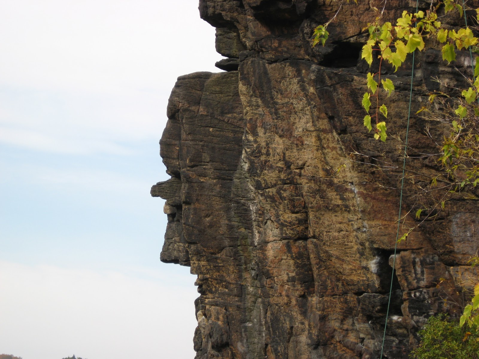 |
| Moss island in Little Falls New York is looking to be certified as a NP. One feature of this place is the stone face reminiscent of New Hampshires |
The final landscape type I want to discuss is our current cultures. The mid 20th century brought on a whole new meaning for the landscape. We moved away from real earthwork projects of the Romantics by developing the landscape to fit our current civilizations needs. The first way we did this was losing sight of the city and developing on the areas between urban and wilderness. Humans first had to build structures to defend against the landscapes processes and it has evolved into being so spread out that our design for the landscape imposes necessary egress routes to get us from point "a" to point "b".
To bring this article to a final summation it is important to know that all landscapes having meaning and this is because landscapes can be read. Past generations have interacted with landscapes and by doing so have made them significant.
Sunday, March 6, 2011
cultural landschaft.pt one
While I never made it to Aarhaus I did make it to the Danish village of Dysskilde. I heard about it first from a fellow American design student, and it peaked my interest so much that I eventually travelled to Dysskilde. This area is deemed an ecological village which by Robert Gilmans' definition is a balance between the human scale and an attempt to integrate into the natural world.
As an interesting by-product of the two previous factors an ecological village is a place where you can showcase vernacular architecture. This term can be boiled down to two factors what is the climate like? The other being what are the natural resources? So an eco-village would then be built by locals that understand the land, environmental factors, as well as designing in a sustainable way that uses local resources.

As an interesting by-product of the two previous factors an ecological village is a place where you can showcase vernacular architecture. This term can be boiled down to two factors what is the climate like? The other being what are the natural resources? So an eco-village would then be built by locals that understand the land, environmental factors, as well as designing in a sustainable way that uses local resources.
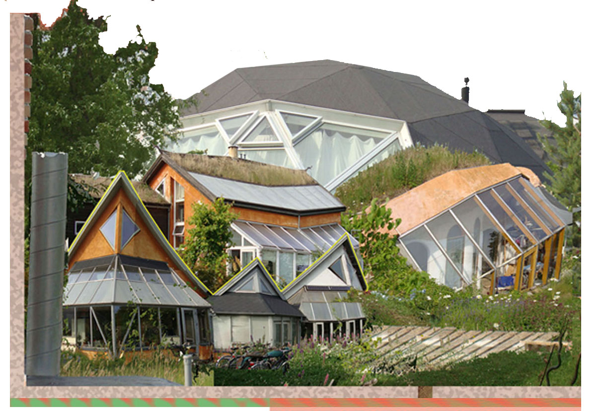
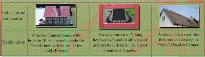
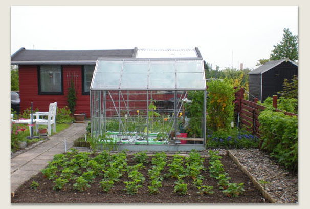
Dysskilde is a all year round residential kolonihave. The collage pictured to the right are some of the examples of typical homes found in this neighborhood. Some homes are built out of clay that was originally sand which was moved when the foundation was being laid out. Homes here often have roofs built from twigs, straw, or sedum this is to regulate temperatures through out seasons. The windows on the homes are designed to capture the most of the suns southern exposure. Chimney's are placed in the center of homes to maximize heat distribution.
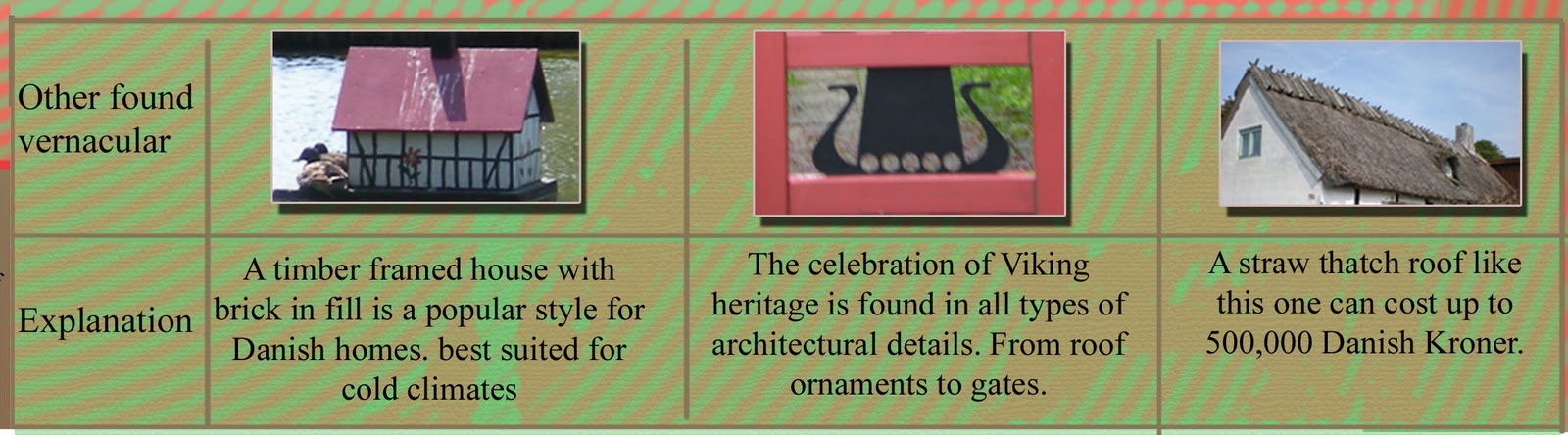
The Danish vernacular and cultural landscapes live outside of these private communities. For example they can be found as part of a collection for a museum, and there are also individual home owners that use these styles to celebrate their heritage.
stuck in the middle with you.


One community that I chose to focus on was the Amager Faelled Kolonihave, the red. These allotments in particular have been relocated once and has had new infrastructure, the yellow introduced around it. I first thought that the residents would have protested and fought back against these new developments but through an interview I found out that they had a very nonchalant attitude surrounding their situation. The resident I talked to said that it wasn't issue for them that they had to move to make room for a preschool or to have the metro right across the street from them. I asked her how she felt all of this happening around her. She said that once she enters the kolonihave gates it brings her back to, what I interpreted through gesters, as her serene center. She said that it only helps her to focus harder on her tending her gardens.
As a side note I searched through the Copenhagen Post and found an article that mentioned an Aarhaus allotment community that was moved 40 meters in 1933 to make way for an extension of local zoo.
As a side note I searched through the Copenhagen Post and found an article that mentioned an Aarhaus allotment community that was moved 40 meters in 1933 to make way for an extension of local zoo.
CPH edition: What's growing in your backyard?
 |
The first Kolonihave I encountered. |
Denmark has approximately 6,200 allotment gardens they can be found in all different types of spaces. Often times new structures are built surrounding the communities without any thought for how it will affect the microclimate of these small scale farming communities.
On Orestad, a suburban island of Copenhagen I studied two separate kolonihave translated from Dansk, to allotment.
I remember vividly the first time I encountered what was soon to be labeled kolonihave. It was the end of the first week of being in Copenhagen and I had decided to take my daily walk behind the apartment. As I turned a corner I couldn't believe what was in front of me. Right off of a busy residential road, essentially a boulevard, was a dirt and gravel path that lead to an entire community built around the principle of farming. As I explored Denmark over the next three months I drifted in and out of these communities and saw how the urban fabric was designed around them.
 |
| Names of vegetables translated into Dansk |
Through interviews with residents I developed even more of an appreciation for this type of community. The first interview happened during my initial encounter with this new and mysterious landscape. I was approached by a middle age lady who wanted to know what I was doing in her community. As I learned from her, these communities are victims of vandalism by local teens. When I explained my purpose of being in Denmark she became very receptive to questions I asked and filled me in on the gossip of the kolonihave.
She explained to me what she grows- berries, and what her neighbors, the young couple with a new born, herbs, the 84 yr old, who gardens to stay young, rhubarb and kale, and the man at the end of the lot who grows his own grapes to press into wine. She spoke about how the community gets together to share the harvest. Despite a language barrier we were able to point out and identify plants.This was one of many people that I encountered through out Denmark.
double U.
The theory of Unitary Urbanism is a basic critique of the urban fabric. Ways of looking at the city through this critique include the notion of the modern city as a museum for tourist, the lifestyles of the city's citizens, the introduction of modern play into city life, urban sprawl, the car, and the role of public space as the theater of life.
They felt that the city was turing into a static object, like our National Parks (ref to landschaft), by becoming an area that bureaucrats who control money and have power, decide what we should look at and what will bring in the most money. The situationist felt that the city should be given back to those who know it best and have quilted themselves into the urban fabric. While the situationist interacted with the city and its resident they were still critical of the residents themselves. They studied citizens at random to see where they went over the course of weeks or in some cases months. In one stand out study they asked an outside friend, a student, to map her walking path for a three years. The end result was her, the majority of the time, leaving her home going out to eat and returning to her apartment. While this may sound unbelievable it still happens today and is even worse when looking at shopping center/ apartment complexes: where one can take an elevator to work and grocery shop and grocery shop next door. I understand that one purpose of a city is to centralize and to increase efficiency, but at least in a city you have to go outside.
This then goes into the issue of urban sprawl. When a cities population grows it can either be up, or out to often it is out. As a city grows the residents need to be able to get to the city faster and more efficiently thereby perpetuating the car culture. Some solutions they propose as a solution for the car culture was having only a fleet of taxi's in a city or having every car on the street be public property so you could hop in, get to where you need to go, drop it off anywhere and go on to other business.

To the left is an image from my final project that illustrates several points about a typical Copenhagen street scene. The building adjacent to the red car is an example of Copenhagen's' green walls. This makes building facades more whimsical and can change on a seasonal basis.
The black and white buildings illustrates the ample amount of green space found in various housing communities of Copenhagen. Danish planners realize the importance of open space in the urban fabric as the place for people to learn and share.
Others that are more tough to represent are soundscape. I have encountered this type outside of various subway stations, universities and regional rail ways.
Others that are more tough to represent are soundscape. I have encountered this type outside of various subway stations, universities and regional rail ways.
Tuesday, March 1, 2011
a more holistic view.

For the next scale of the project the studio collaborated with graduate architecture students over at Syracuse University. The studio professors divided 27 students into five groups and collectively as individual groups we had to decide on an issue that affects the Central New York Market (CNYM). Through a lot of brainstorming we ended up deciding to look at the factors that make a market a market. Issues that others focused on were the flows of information and transportation.
Factors that I looked at, and represented in the accompanying images, were identifying where the major aquifers and geologic deposits are in CNY this is a step to better understand what crops could be grown in the region to eventually expand the agricultural base. Then I identified the other
year round food markets in other counties and finally did a graphic looking at what counties
the CNYM would be serving.
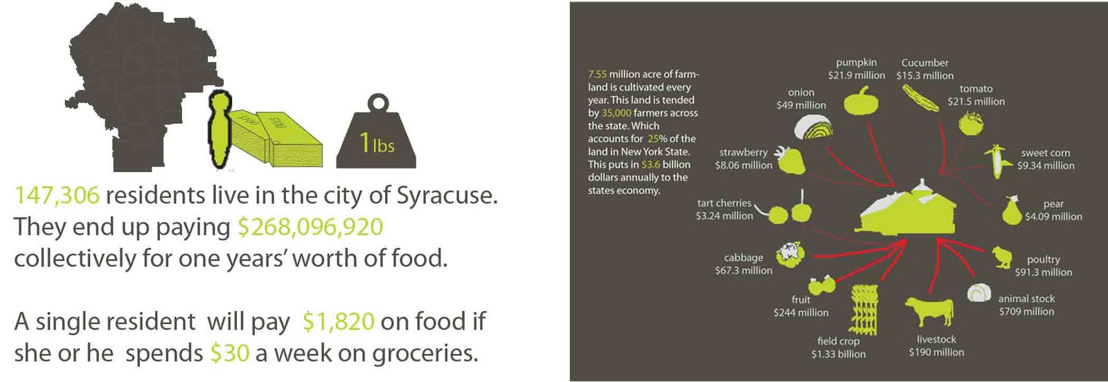
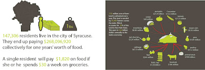
The above graphic looks at what the average Syracuse resident annually spends on groceries. The weekly total was taken from my weekly grocery receipts and did some math to figure out yearly totals for various population scales. A missing metric to this graphic is that the average person in the USA consumes 440 lbs of food a year.
The graphic with the dark grey background looks at the number of farms operating in NYS and how much food, in terms of dollars, they produce in a growing season.
the historic-market walk
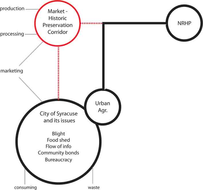 This project never came to fruition and what I mean by that is nothing more than this graphic came out of this idea.
The principle behind this is that there are historic properties that are on a local or National Register of Historic Places that have become an eye sore for the residents of towns and cities. Combined with the issue of urban food deserts- these places can become an asset to the community.
The idea I am getting at is if agriculture joined the local preservation movement and cultivated the historic landscapes in a way that reflects the original garden /lawn/landscape intent. Cities can use land to educate the community while celebrating all types of heritage. In several unrelated examples a historic Italianate landscape is all greenery and no other color accents. An adapted-cultivated reuse would be planting cabbage, artichoke, or kale in long carpeted spreads. The other not shown example is of a Greek Revival; normally plantings are far away from the foundation, four paths that make a cross, and a fruiting or nut tree as a center point of this symmetrical design. The four separate plots of land can let a farmer rotate crops and the focal point could be an apple tree if for example in Central New York.
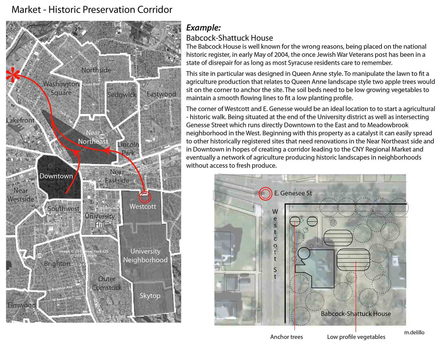 The example pictured to the right is an abandoned and derelict property on the NRHP. Regardless of the current state, the opportunities is there. Within walking distance between University Neighborhood and the Near Eastside it can weave in and out of biking paths, other historic properties, parks, the Connective Corridor to melt and weld this idea of historic agricultural production with the modern network of landscape elements that Syracuse has to offer.
*As a side note and afterthought the building reuse could be handed over to the preservation offices, but ideally it would be used for food storage, processing, consuming or marketing.
precedent on a macro lvl.
In this next phase of studio we looked at certain components of the Central New York food system. We divided into groups that were to collaboratively focus on topics of the topics of the regional market, urban agriculture, and the group I was in regional food production. Through discussion we broke regional food production down again- into separate topics of garden cities, food shed design, and suburban agriculture. We decided who in the group would be responsible for what case studies could be applied to Central New York. I decided to look at suburban agriculture.
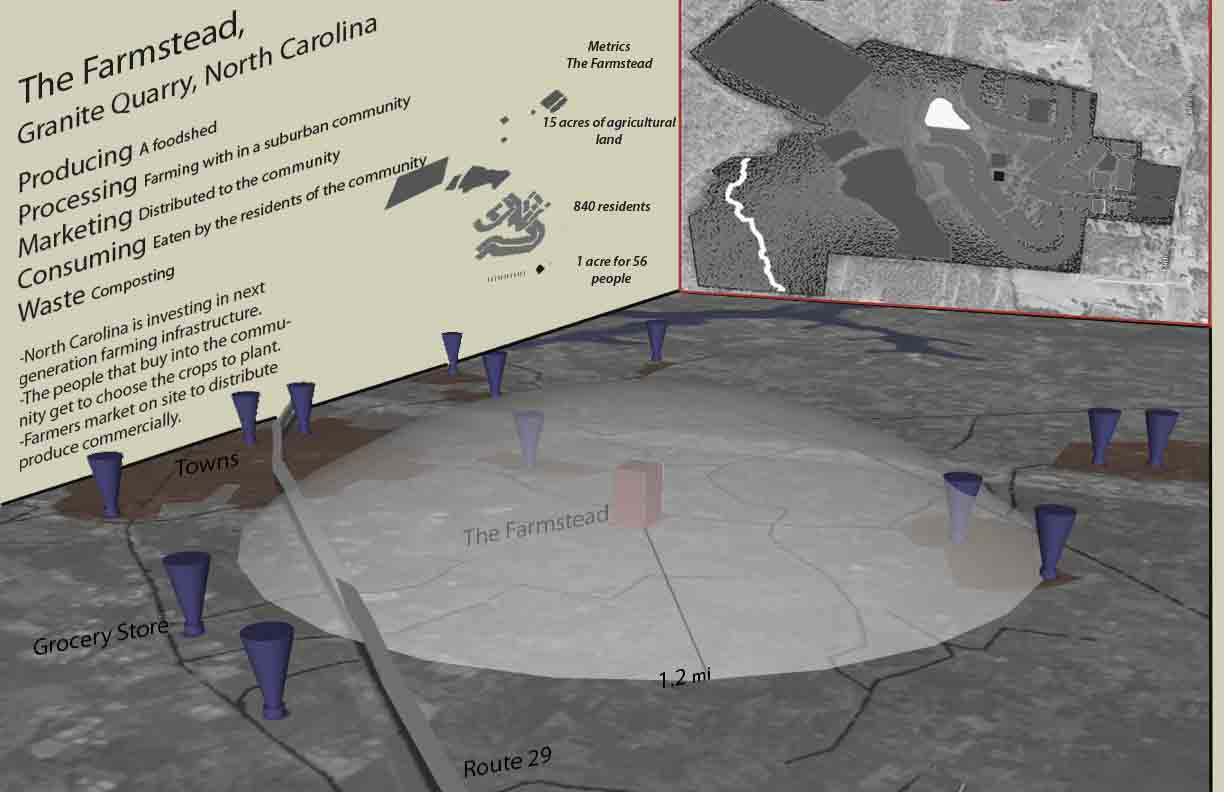
Represented to the left is Granite Quarry in North Carolina. I made an inventory of the grocery stores with in a mile radius of the 128 acre suburban farmstead, represented in red. While a step in the right direction it is in my opinion, not the best model. It was poorly executed and if you have read one of the most recent Landscape Architecture Magazine's, the community collapsed financially.
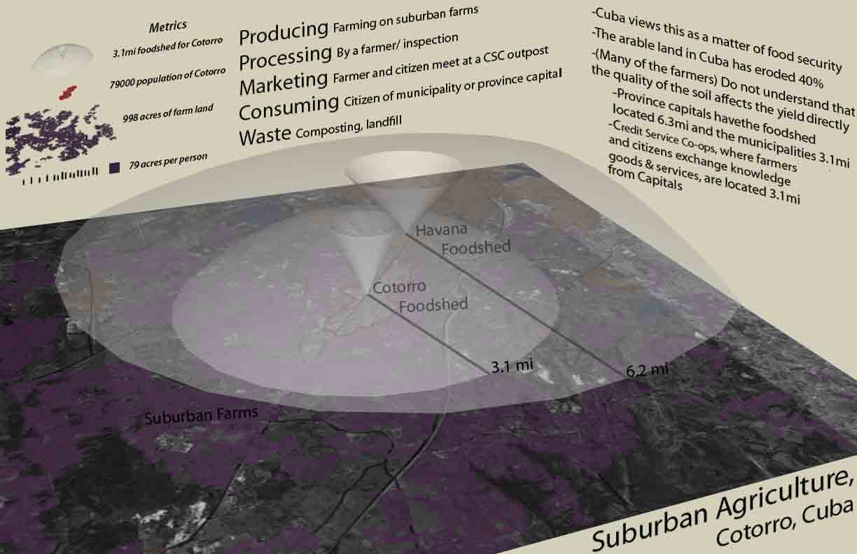
Represented to the right is Cotorro, Cuba what I would call a better model for the Central New York area. They are currently building a farming web outside of municipalities which then feed a larger food web that goes to capital provinces. This is all in an effort to make the country food secure.
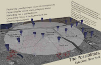

As a final synthesis of the previous precedents I applied what I learned to the local scale of Syracuse, New York. Similar to the procedure of the Granite Quarry case study; I inventoried marts that sells food. If you noticed I did not use supermarket instead I said mart. This is because this portion of Syracuse is considered a food desert.
Syracuse also has 3,500 vacant properties, estimation highlighted in red, which can open up design opportunities by bridging disciplines.
thinking in systems.
This years studio focuses on regional foodshed design. As you might imagine looking at a foodshed is daunting so the the studio is broken down into groups to focus in on specific scales which a foodshed operates on. My contribution to this project is documented in the following blog posts
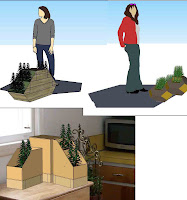

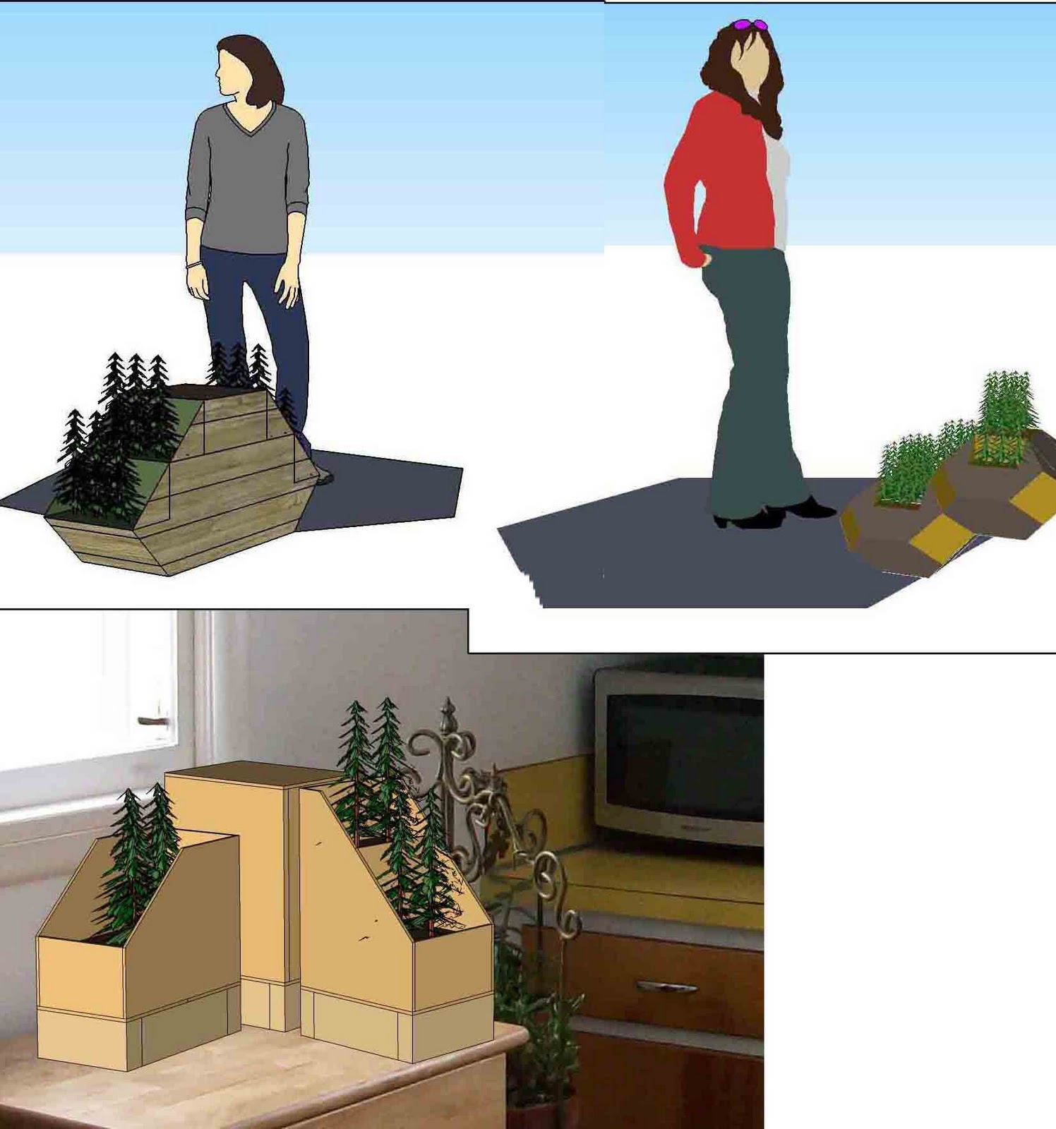
The first project of the semester focused on the idea of a system being the concept for design. I was paired with an MLA who has an undergraduate in marketing; the idea that came to this person was having a composting unit that could be on a kitchen counter. Through brainstorming with one another, we decided on what we call the Kitchen Companion.
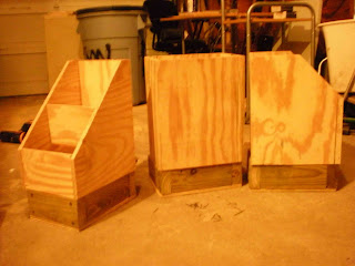 It is a composting unit that is coupled with two planter boxes that can grow three different types of vegetables, that you would harvest after a growing season, cook in a dinner and and then place the waste in the counter top compost unit. Over time the soil would be changed out with the compost material of your leftovers from the meals you prepare.

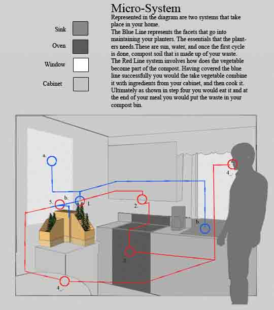

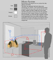
The scale that is not represented is the macro scale. This scale would start to represent the community around the kitchen companion. Some of these factors are the trucks and infrastructure that process the food, the delivery of food from the farm to the distributor, and how the consumer decides to get to the supermarket.
Subscribe to:
Posts (Atom)